Showing posts with label biking. Show all posts

Saturday, May 19, 2012

Miami & Erie Canal at New Bremen, Ohio

 I decided to pay a visit to a relatively easy hike but moderate walk along the historic Miami-Erie Canal starting at New Bremen (pronounced Bree-man), Ohio down to Minster, Ohio.

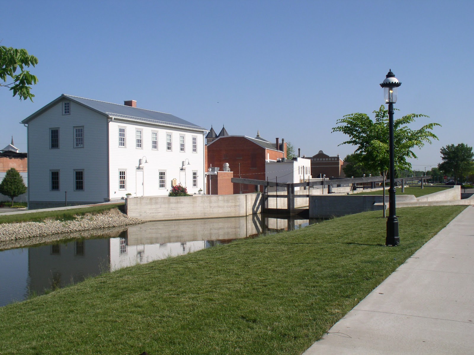
The photo on the left shows Lock 1 North which is located in the heart of the town. The large building to the left of the lock is a reconstructed lockhouse which looks similar to the original lockhouse. The lock has been cleaned up and reconstructed to provide a view of how it was constructed. The original lock was built out of limestone whereas the new one is poured concrete. The locks themselves are similar in construction to how they were built and how they worked.

History

The history of the Miami-Erie Canal in western Ohio is a feat of engineering of the time. Construction began in the early 1820s starting on a leg from Cincinnati to Dayton.  This leg of the canal was a boon to industry in the area for providing goods and services that extended to the Ohio River. The small town of Franklin became a center for trade shipping grain, slaughtered hogs and other goods. To ride the canal boat from Dayton to Cincinnati made travel easier than the alternative stagecoach at the time. A fast trip by canal boat could take only 20 hours!

In May, 1828, Congress signed a grant giving 50,000 acres of land from Dayton to Defiance that was used to complete phase two of the canal called the Miami Extension. Finally in 1831, an additional grant was given which would extend it to Toledo. The complete construction took 20 years. There were 19 aqueducts which were built over some creeks and rivers and 103 canal locks, of which this one at New Bremen was one. Bridges that were built were either swivel or were built high enough for a canal boat to go under.

Today

New Bremen has restored their lock and cleaned up the canal making sure within their city limits, the towpath is clear along the canal. The towpath has been covered with a fine grain crushed limestone which makes walking, running, or riding bicycles along the flat level trail easy. 
The day I was there was bright and sunny. The walk from New Bremen to Minster is about four miles. The path crosses one road through-way, but  except for that the complete path is over this crushed limestone, making it an easy walk.

Once you leave the city limits, the towpath stays the same, but the canal is generally neglected and as you can see in the photo on the left,
there are now trees growing between the path and the canal itself. On a day like today the canopy provided some relief from the hot sun. I began at about 9 in the morning so finished fairly quickly depending upon your pace. It was a Saturday and there were a few runners and several bicyclists, but otherwise, the path was pretty much my own. While technology moves on, it is sad to realize that the canal nearly disappears on this walk sometimes due to over-growth reducing to a small stream.
Generally it is stagnant outside of the city as there is virtually no circulation of the water even though there are now a few small streams emptying into it. Here is what it looked like in some areas, overgrown with cattail plants and lush greenery. Most of the landscape is either farmland on one side and occasional houses or small industrial facilities on the other.

While there are lots of birds along the walk, the insect population seemed very low despite the temperature being in the eighties and next to the stagnant areas of the canal.
Occasionally, there were pleasant surprises as this large turtle sitting by the edge of the path. I wasn't sure what he was up to as I would have thought he was dead except his eyes were wide open and he was just sitting there. Either he was warming himself, or laying eggs. While I don't know turtles, this could have been a box turtle because I know they lay eggs in the spring.

Historically along the canals there were different industries. As I mentioned above, several were grain and slaughtered hogs. Another one was ice. Plants were built that housed ice which was covered with sawdust, stacked and loaded onto canal boats to be delivered to southern climates where ice may not have been as plentiful.
Along this walk was a restored building that used to be an ice facility. It was right next to the canal. The photo was taken slightly down the road near where there historically was a swinging bridge which allowed canal boats to pass or traffic over the canal.

As the walk came to an end just outside of Minster, one could continue into the town, but much of the walk would be along a road.
Sadly the canal at this point became mostly a drainage ditch with most of it covered up. This is supposed to become a small industrial park. The picture was taken at the road and behind me, not in the picture is a home built next to the former canal and a portion is part of the home's yard. No sign of the canal exists.

All along the length of the whole canal from Toledo to Cincinnati there are portions that still exist, sometimes in ruins. In other locations such as in Dayton, a road now runs the path of the canal. For some additional photos of the canal along the complete original path, there is this web site where you can even see pictures of New Bremen's lock before it was restored.

The area on which I walked is part of the Loramie Summit, the highest plateau of the whole original Miami-Erie Canal. It was a 21 mile plateau that was controlled by the lock at New Bremen and Lockington, Ohio. The summit section was fed by Indian and Loramie lakes. It raised the boats up to 513 feet from the start at Cincinnati and then down to 395 feet at Toledo.

If you like a bit of history and want to get some exercise, this is generally a pleasant place to visit. I would recommend April or May depending upon the complete season to avoid humidity and potentially mosquitos and gnats.

Thursday, March 11, 2010

Can Spring Be Around the Corner?

Now that our snow has begun to disappear and temperatures have been in the sixties for several days, it seems only a matter of time before nature begins is renewal cycle. Last week I visited a place I hadn't been to in months. In fact it had been long enough that I had to re-check my maps on where exactly it was located.

The site is the Caesar Creek Nature Preserve. Within a short distance from me is the Caesar Creek area, where in the late Spring and Summer, large quantities of people come to enjoy their foray into the natural world. It is a huge boating area. But this is not the Caesar Creek area I usually travel to. The Nature Reserve area is south of the main vacation spot and has two elements that make it more ideal for hikers who want to commune with nature. First of all, it is connected to the Little Miami River bike path and the parking lot is a place for bikers to leave their cars as they ride the bikeway (a very nice area to bike, by the way). Secondly, this Nature Preserve does not allow bikes or pets in the wooded area, so it isn't as popular for the casual walker who wants to spend some time walking their pets.

When I went there last week, it was still cold (a good time to hike) and as I said the snow was receding, but unfortunately, it was warm enough that some of the icy pathways were turning to mud, making for a messier hike. But it was another quiet peaceful time having the preserve to myself practically. I met one soulmate on the path who also liked coming for the isolation and sense of private ownership.

As with many of the parks and preserve that straddle the wonderfully scenic Little Miami River, it was an opportunity to hear the sounds of nature as it begins to adapt to the coming rumble of nature springing into life. The trees had small buds that were forming as they prepared to burst into small leaves. The ground was soaked with wet much needed to the renewal process. I intend to spend some frequent visits to the area as it transforms itself into a fresh smelling area with wildflowers and other flora.

Saturday, February 27, 2010

A Winter Visit

"I prefer winter and fall, when you feel the bone structure of the
landscape - the loneliness of it, the dead feeling of winter.
Something waits beneath it, the whole story doesn't show."
- Andrew Wyeth


There is something wonderful about winter, when nature is in solitude, the beauty in its decay. Nature gives off the vibrations of things to come as winter withdraws and we are teased with the coming of Spring.

I enjoy going into the woods on a snowy day when sounds are muted and the birds can be viewed through the leafless trees and their songs clearly echoing throughout. I have been cooped up for a number of weeks due to the unusual volume of snow our area received over this past month of February. It was the second largest recorded snowfall over the month with over 21.4 inches mostly without much melting in-between. Today I awoke to a fresh 2 more inches on top of the already packed snow, so the woods had a fresh cover of the white stuff.

While I love hiking through woods when Spring is in full bloom, it is hiking in winter that adds the tension of things to come. I traveled nearby to Sugarcreek Metro Parks, a normally easy hiking area. It is also very popular for moderate hiking enthusiasts as well as - mostly in the Spring - runners who are looking for more than the hard streets. Today started out with only a few souls visiting the park, but by the time I left, a hiking group had moved in and things became much busier. This particular park offers at least a 3.5 mile trail which follows a small creek but also at times runs up against an isolated housing area. Still for a quick visit to nature, it is a pleasant place to go.

Today the trail was rutted and tromped down by previous hikers making it just a bit more difficult and easy to turn an ankle if one is not careful. But all things considered, it offers the starkness that only nature in winter time can present. One pleasant surprise was when I came upon a Pileated Woodpecker drilling for insects beneath the bark of the trees. I took some great video of the bird in action. Pileated woodpeckers are the largest species of woodpecker in North America and have a distinct red top to its grey coat which moves to a black and white striping of its head. The bird kindly worked from my angle of vision so that I could capture it at work.

My time out today helped give way to the cabin fever I have felt over the last month as I count the days before nature begins to break forth with early blooms and the overcast days become more sunny as the earth moves into position where the angle of the sun gradually begins to warm the ground and natural life begins anew.

Monday, October 26, 2009

Germantown Metropark & the Twin Valley Trail

“The spirits of the air live in the smells
Of fruit; and Joy, with pinions light, roves round
The gardens, or sits singing in the trees.”
Thus sang the jolly Autumn as he sat,
Then rose, girded himself, and o’er the bleak
Hills fled from our sight; but left his golden load.
- William Blake (Poetical Sketches)


A week ago I spent a glorious mid-week (one of the best days of the year) on a walk practically in my backyard in one of the metroparks created and managed by the Montgomery County, Ohio parks department. The county, which neighbors mine, has some excellent moderate hiking areas as well as biking (if you are interested).

This particular day, I traveled to Germantown Metropark in southern Montgomery County near the town of Germantown.
That village is a historic area that was founded by a migratory group of (what else?) Germans who settled the area having traveled from Pennsylvania. Germantown Metropark is probably the best of the county's park system for hikers. There is almost a little of everything for the backpacker (including camping). The park straddles a very clean Twin Creek and ties into the Twin Valley Trail which is south of Germantown. The main metropark itself has nearly 14 miles of hiking trails through spectacular scenery. There are ravines, large mature trees, wildflowers and steep topography making these trails sometimes a challenge to regular backpackers. You'll also see fabulous grassland prairies, ponds, dry hillside prairies and assorted flora and fauna.

I traveled there, as I mentioned, in mid-week and right at the end of the fall leaf spectacular. The place was practically my own as the shorter four mile hike I took I nary met a one on the trail. The trail itself wound up and down the ravines and was at times hard to follow due to excessive leaf fall. Luckily, they have carefully marked points so you will know you are still on the correct trail.

I traveled an area that is part of the Twin Valley Trail, though I was still north and west of Germantown. I began just off Old Mill Road where I parked and began the hike south toward State Route 725. It is a two mile hike to that point and then looping back, the repeat two miles makes for a couple hour walk especially if you regularly stop to enjoy the sites.
At the point of the Old Mill Road, walk about 100 feet to the picnic tables that are there before you begin your hike and look at the Germantown dam and spillway. It was built around 1920 after the devastating 1913 flood. If you travel through Germantown heading west to Conservancy Road, you'll actually drive over the dam and be able to see its highpoint view before arriving at the parking point.

The hike begins at this point and if you travel up the ridge, it begins almost immediately to wind to and fro as you traverse gradually up the ridge. This area displays younger trees and thin coverage, but definite isolation.
The trail is a small backpack trail scraped out and generally smooth walking though with lots of uphill climbing. Gradually you reach a highpoint where it gradually begins to take you back down toward Twin Creek. Were it not for the markers or without a GPS or compass, it would be easy to get waylaid.

There were times that the woods increased in density and it was during this time that I heard some snapping of twigs. Turning I could see three deer making their way toward food? home? I must have been downwind form them because I thought I was rather noisy until I heard them and instead of me, it was the sudden cry of a bird that spooked them onward.

As you find that you are gradually working your way back into the bottom lands toward the creek, the pace quickens. The trail eventually takes you creekside into a calm, quiet area where the clear creek passes. It is said the creek is clean enough to be able to drink from safely. Agreements have been made with landowners to limit their agricultural uses. And while they recommend the water first be boiled, it can be used. When I was there, the creek was very low, and even though it is regulated by the dam, water levels have been low in the area.

Once more the trail begins to take you back to the top of the ridge in even denser woods as the trail meanders through before you reach the area where backpackers can camp for the night if desired.

This is final 1/2 mile or so of the hike before reaching State Route 725. The trail continues to wind its way down until
suddenly you are in the bottoms and the area opens into a vast field of prairie grass. When I was there, the sound of an eagle hovered overhead as it searched for its prey. The rest of the hike up to the road transition to Twin Valley Metropark where the trail continues is flat but tall grassland with the creek to your right. I continued on until I could begin to hear the sound of the vehicles passing along the road. At that point, I turned around and retraced my steps back to my car for a total hike of 4 miles.

I was only touching the beginning of this rather vast parkland and I was not in the best of it. That is to come another day. Perhaps, I'll try it first as an early winter experience returning later again in the Spring of a new year.

Sunday, October 11, 2009

Tecumseh and the Shawnee Village of Chalahgawtha

The Village of Old Town on U.S. 68 north of Xenia and right along the Little Miami Bike Trail near the Old Town spur where you can park your bike is also the historic location of Chalahgawatha or Old Chillicothe, once the main Shawnee village in the 18th century. U.S. 68 is historically a Shawnee trail running the length of Ohio (Bullskin Trail) and at the confluence of the Little Miami River and Massie Creek is where the village was located. There is a lot of history in this location.

Both Daniel Boone and Simon Kenton were held prisoner at this village and Kenton was forced to run a gauntlet here of about 200 yards.
There are historic markers so that you can get an idea as to location and distance. The primary site is now where the Tecumseh motel is located. If you either park in the motel lot or if traveling by bike, park at the spur and walk over to the location, you will find a number of markers pointing out the historic facts.

Looking behind the motel across what is now farm land, there is a rise on which the council house of the Shawnee stood. The village of Chalahgawatha had been destroyed several times and rebuilt by the Shawnee. One particular incident if noted on one of the markers.
This was the event where 10 Kentucky soldiers were killed in 1779 during an attack on the village. The marker unfortunately does not tell the whole story. Col John Bowman, commander was jealous of the fame George Rogers Clark had received in his capture of Vincennes from the British forces. He decided he would assemble volunteers to move against the Shawnee village at Chalahgawatha. What he did not know was that the Shawnees had split and half of them had moved to the west of the Mississippi and the rest of the primary braves were away from the village leaving mostly young boys and elderly. As Bowman moved against the village, he failed to keep silent and early warning of the soldiers' approach was heard by the tribe. Fearing they were going to be massacred, they moved to the council house where the women were singing the death chant. While Bowman's forces burned the wegiwa (teepees) belonging to the individual families. As they burned, they looted and during that time, the ten soldiers were killed by the few Indian gathered in the council house. Fearing a much bigger force, Bowman hesitated and ordered a withdrawal. Realizing they had the upper hand, the young Indian braves gave chase and killed more as the soldiers continued to retreat.

This is a historic area. Besides the terrible loss of the ten Kentucky soldiers, near this location the great Shawnee leader, Tecumseh,
was born near a springs about 500 feet away at the Old Town Preserve area. There isn't much to see in the location unless you have an active imagination and can try to imagine what the area looked like at the turn of the 18th century. But to stand in these shadows and think about the history behind the tragic events of the American Indians and the eventual domination of the white settlers, one cannot help but be moved.

Saturday, September 5, 2009

Caesar Creek Nature Preserve

"Large, placid mulleins, as summer advances,
velvety in texture, of a light greenish-drab color,
growing everywhere in the fields..." - Walt Whitman


With the Labor Day weekend upon us and a series of non-stop beautiful days, I was looking for someplace to go and spend some time with nature. I wanted someplace different from where I had been. I considered heading to nearby Caesar's Creek State Park, but figured a lot of people would be there for the last big weekend of the summer. I also considered going to Ft. Ancient east of Lebanon, Ohio, but figured it wasn't much for hiking. Wanting to stick to the Little Miami River area, I discovered something in-between called the Caesar's Creek Nature Reserve. It spoke of about 2 miles of hiking trails and mention of a gorge area, so I hoped it would have some character to the area.

After a pleasant drive down State Route 42, I veered off a road just Southeast of Waynesville. Following it south and slightly east, I turned onto a small township road that was lovely just for a drive with the sun dappling the road through the many trees. After a few turns and twists, I found the Nature Reserve and parked. Only a few cars were parked there and those were mostly people who used it as a starting point to travel the bike path that is part of the 70 mile long and 66 foot wide Little Miami Scenic River State Park.
The entrance to the hiking trail begins in a wide swathe that leads to the primary trail. After a short quarter mile hike up this access area, the trail veers off to the left. Before I reached it, I could step a little off the access area and see the expanding valley floor, tree-filled before me.


The trail is a narrow downhill path that is a bit rough in the beginning as it heads down into the valley floor, where it widens a bit into an easy, generally flat trail blending through the trees. The sun through all of the leaves left dappled spots of bright light as I passed through the initial trail. This part is moderate and wide enough that there are occasionally joggers who like to be challenged. I don't recommend it since portions of the trail does have rocky areas sticking up that a mis-step could cause an ankle to twist if not careful. Despite it being the Labor Day weekend, this hike took me past only one person. I was pretty much left to my own in this lovely natural area with a few wildflowers still in bloom as the woods turn to goldenrod, Queen Anne's Lace and many bees going about their business. There were some fields of mulleins in their still late stage, nearly without flowers and going to seed; scattered pokeweed with its deep purple berries ripe for the birds - all early signs of fall.

The trail as it continues along a flat path soon begins to touch near the Little Miami River. This is such a peaceful river this late
in the summer with the river bugs - Mayflies and Dragonflies along with the water spiders skiping across the still river. The trail is so close to the river, it is easy to take short cuts through traces of paths up to the bank. Along the bank, it appears to have a small trail to follow in places that parallels the primary trail. I kept going over to the river in various places just to stand and observe nature in its late summer glory with the only human intrusion besides myself, being the sound of small planes overhead from the nearby Waynesville airport.

Eventually, the trail begins to turn away from the river and the texture of the trail becomes more rocky. Suddenly, as you find yourself heading up the slight beginning of the climb to the ridge, it does a near u-turn and follows a more gradual,
but breathless inducing climb up the side of the ridge. I didn't have my GPS with me, so I am not sure exactly what the elevation change is, but the climb is somewhat fatiguing for the casual hiker. Eventually, the trail reaches a level point for about 100 feet before it begins one last climb to the ridge. Upon reaching the ridge, one returns to the expanded trail that appeared to be for Park vehicles if need be. I decided to follow it the opposite way for about 500 feet and soon found myself in an area where the texture changed from deciduous trees to pine trees that appeared to be in a severe state of drought or dying. It was sad to see so many in this state. I turned around and followed once more the trail back toward where I began.

Caesar's Creek Nature Preserve is a nice short hike getaway that doesn't appear to be on the radar of many visitors since hiking would be the only sport allowed. It does bring you close to another area of the simply wonderful Little Miami River with its historic aspects. The river has played a big part in the settling of area, first with the migrating Indian tribes to the white settlers who later followed.