Thursday, February 25, 2021

Site of Old Chillicothe to become a State Park

It was announced today that the State of Ohio will turn the site of Old Chillicothe into a State Park. Now, visitors will be able to walk the same area that once was the home of some of the Shawnee tribe during their stay in the area. What is now called Old Town, Ohio sits on U.S. 68 between Xenia and Yellow Springs, Ohio. U.S. 68 was once an old Indian trail running from the Ohio River toward the Lake Erie.

At the time the Shawnee lived there, pioneer Daniel Boone was once held prisoner there as were other white men. More on this historic site can be read in a previous post.

Tecumseh and the Shawnee Village of Chalahgawtha

Friday, February 21, 2020

Under the cloak of winter lies a miracle

"Every gardener knows that under the cloak of winter lies a miracle ... a seed waiting to sprout, a bulb opening to the light, a bud straining to unfurl. And the anticipation nurtures our dream." - Barbara Winkler
While I am not a gardener by nature, I am a fan of nature and watching things grow. Nature has always intrigued me watching the cycle of life as I continue to grow older. This week, I revisited a nearby Reserve just to get out in the sunnier but colder days. Our February around here has been nothing but grey upon grey days and it was good to not only see the sun making efforts to break out but also to be out in it as it does. Monday was a partially sunny day, but Friday was a sparkling delight.

This shot was taken in what is normally a bright grassland prairie within the Reserve.
Winter has a way of showing nature in repose but also filled with promise. February is particularly attractive to me as it is the month of my birth. But it is also considered one of the cruelest months here in the Midwest when the snows can be the heaviest and the temperatures the coldest. Whether you abide by the theories of global warming or not, these past years in February have been abnormal. Normally there is lots of snow on the ground, but this year we have had barely any accumulation of the white stuff.

Going back to the Reserve on Friday, it was a remarkably clear but very cold day with temperatures hovering in the teens.
I love hiking on these days as the place seems to be only for the brave. The ground in early morning contained delicate ground sticks embraced by spikey frozen frost along the pathway. Many of the dormant plants were filled with bits of frozen water from past rains.


The Reserve contains some beautiful examples of nature including those developed by man. It contains several ancient giants of nature – massive Oak trees over 550 years old.
Originally one of three large Oaks in the immediate area - they were called the "Three Sisters" though years ago lightning brought down one of them. Though only two survive, the name remains.


There is also the Osage Tunnel, a human manipulated row of Osage Orange trees creating a natural tunnel as one walks through it.
Though the squirrels and other creatures take care of cleaning up, these trees produce large orange-shaped fruit which fall all around them.


Author Edwin Way Teale wrote: “Our minds, as well as our bodies, have need of the out-of-doors. Our spirits, too, need simple things, elemental things, the sun and the wind and the rain, moonlight and starlight, sunrise and mist and mossy forest trails, the perfumes of dawn and the smell of fresh-turned earth and the ancient music of wind among the trees.” This is why I find hiking in winter particularly refreshing. Ohio has much to offer to one who is willing to get out, embrace the cold, and spend time privately communing with our Mother Earth.

Wednesday, March 30, 2016

Spring return to Caesar Creek Preserve

Spring, the sweet spring, is the year’s pleasant king,
Then blooms each thing, then maids dance in a ring,
Cold doth not sting, the pretty birds do sing:
Cuckoo, jug-jug, pu-we, to-witta-woo! -- Thomas Nashe
As I return to an old friend - the Caesar Creek Preserve, south of the rather large Caesar Creek Reservoir, the coming of spring is definitely in the air. The day was quite cool as early spring is shaking the last vestiges of winter from her hair. This preserve is almost like a secret garden for me.
I rarely see many hikers in the area as most seem attracted to the Reservoir north of it. This small preserve has the Little Miami River Bike trail nearby, but usually the only vehicles in the preserve parking lot are bikers who use it as a starting point for their ride. Today, the only other person in the preserve was what appeared to be a videographer working for the State of Ohio. This preserve skirts the edges of little Caesar Creek which is returning to its light run after being dammed up north to create the Reservoir. But today, the creek was rushing as the rains of spring have swelled it to higher volumes. Ultimately the creek runs into the Little Miami River as the confluence is nearby. The creek has swelled to a large volume as it seems in a hurry to race into the larger river. Opposite the creek, a huge cliff rises up and it was enjoyable watching the passing water move steadily onto its destination nearby. A few of Ohio's early wildflowers are
peeking out including the lovely Dutchman's Breeches (Dicentra cucullaria). The trail is wide and for the most part an easy walk though entering into the valley area along the creek means a steep hike back up if you find such difficult. The trail is still muddy as the spring rains continue to drain down to the creek. I look at this preserve as my private domain as it seems little used by walkers and hikers except perhaps the weekend. As Spring continues to develop it is a good place to return to enjoy a little solitude.

Thursday, February 25, 2016

Clifton Gorge in Winter

 A town is saved, not more by the righteous men in it, than by the woods and swamps that surround it. - Henry David Thoreau

 This has certainly been a strange winter here in the Miami Valley of Ohio. I had an opportunity to be by myself hiking six miles of Clifton Gorge and John Bryan State Park near Clifton Mill, Ohio. I've visited these two places often before but hadn't been there in the "winter" time - though it nearly rose to 70 degrees in the middle of February, normally a month of snow in this area.

The gorge as usual is lovely as the winter waters from previous rainfalls continued to storm down the narrow channel of the gorge expanding ultimately into the Little Miami River.
The day was bright and sunny and that Monday morning I was alone in the woods by myself enjoying the simple solitude it affords. The only sound was the rushing of the water as it tries to flow through the narrowed channel afforded by the trace carved into the limestone rocks.

The trail begins near the small town of Clifton Mill about 20 minutes from Xenia, Ohio and close to Yellow Springs, home to Antioch College. The trail splits soon into a rim view or you can climb down via some provided stairs to the river edge trail, which I find more interesting though more difficult with all of the rock pieces and roots from trees sticking out of the trail. This area historically was home to a number of mills all gone now except for the one at Clifton. It was also a trail used by the Miami Indians as well as an escape route by Daniel Boone and Simon Kenton after they had been captured by the Indians when this was only known as the Northwest Territory.

Eventually, the trail in part of the preserve ends at a footbridge and continues as John Bryan State Park. By this point the trail is wider and smoother as it was once a stagecoach trail from Cincinnati to Pittsburgh.  Though it is much narrower now with erosion, it is still fascinating to imagine traveling the area. The river also calms down at this point and even widens into a pond-like portion known as Blue Hole, once depicted in an 1851 painting by African-American artist Robert Duncanson.
Though my own photo does not do the painting justice since trees have grown now on the hill from which he painted, it looks something like this even to this day.

If ever you find yourself in this area, this is a hike worth taking, especially in the Spring, though any season is worth the solitude you feel when hiking alone. Despite life seeming to be asleep in anticipation of the coming of Spring, I was heralded by the selfish honking of geese holding court.

As the snows of winter recede, this is a park to which I will find myself visiting often, if nothing else, but to remind me of my small place in this universe called Earth.

Thursday, December 18, 2014

Sweet Arrow Reserve

A little over two years ago, the township in which I live was given a donation of land both farm and wooded by the late Dr. Dille near Dayton, Ohio. The donation was contingent upon the residents of the township voting to add a tax to develop and maintain a reserve that would include trails and perhaps some other recreational features for its residents and others.

For the next year, it seemed nothing was happening, but then recently, I noticed a small paved area entrance added for small amounts of parking for hikers.  A sign was posted which essentially indicated, the area while open, was still being developed and the initial trails were only marked by small posts with orange flags.

Anxious to check things out, I took a short hike on the land to get an idea of what it was like.

Surprisingly, there are some small challenges as the wooded section includes some hills which are not for the casual walker.  There is a creek that needs to be forded twice and while not deep, currently, at this time of year, there wasn't any simple way to ford without either simply stepping through it, or leaping it, if you didn't have waterproof hiking boots.

The trail is not completely clear and at one point I found myself on what appeared to be a pathway, but there seemed to be no more stakes. Not sure if I was encroaching on private property, I ultimately turned back.  However, it did provide a nice discovery.  An old tree that was hollowed out and had an appearance of what the British call a Wendy house.  It was fun to look at though it did need to have its insides cleared if one wants to step inside it.  It will be an interesting addition for children who are able to hike this portion of trail.

The woods are sparse and the trail is not tough, but the fact that it is so close to my home, I can walk it if I am looking for a quick hike in a very close area to where I live.

I am hoping the trail becomes much clearer over time and it will be fun to visit when Spring returns just to see what kind of flora it supports.  As there are few currently walking the trail, the deer have not yet gotten used to visitors to their former private area and can be regularly seen foraging and running through the wooded areas.

Saturday, May 19, 2012

Miami & Erie Canal at New Bremen, Ohio

 I decided to pay a visit to a relatively easy hike but moderate walk along the historic Miami-Erie Canal starting at New Bremen (pronounced Bree-man), Ohio down to Minster, Ohio.

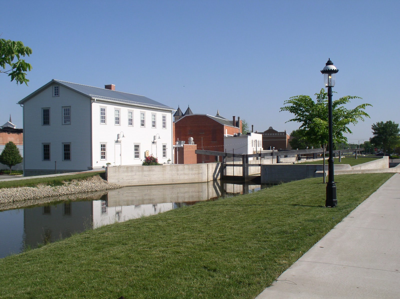
The photo on the left shows Lock 1 North which is located in the heart of the town. The large building to the left of the lock is a reconstructed lockhouse which looks similar to the original lockhouse. The lock has been cleaned up and reconstructed to provide a view of how it was constructed. The original lock was built out of limestone whereas the new one is poured concrete. The locks themselves are similar in construction to how they were built and how they worked.

History

The history of the Miami-Erie Canal in western Ohio is a feat of engineering of the time. Construction began in the early 1820s starting on a leg from Cincinnati to Dayton.  This leg of the canal was a boon to industry in the area for providing goods and services that extended to the Ohio River. The small town of Franklin became a center for trade shipping grain, slaughtered hogs and other goods. To ride the canal boat from Dayton to Cincinnati made travel easier than the alternative stagecoach at the time. A fast trip by canal boat could take only 20 hours!

In May, 1828, Congress signed a grant giving 50,000 acres of land from Dayton to Defiance that was used to complete phase two of the canal called the Miami Extension. Finally in 1831, an additional grant was given which would extend it to Toledo. The complete construction took 20 years. There were 19 aqueducts which were built over some creeks and rivers and 103 canal locks, of which this one at New Bremen was one. Bridges that were built were either swivel or were built high enough for a canal boat to go under.

Today

New Bremen has restored their lock and cleaned up the canal making sure within their city limits, the towpath is clear along the canal. The towpath has been covered with a fine grain crushed limestone which makes walking, running, or riding bicycles along the flat level trail easy. 
The day I was there was bright and sunny. The walk from New Bremen to Minster is about four miles. The path crosses one road through-way, but  except for that the complete path is over this crushed limestone, making it an easy walk.

Once you leave the city limits, the towpath stays the same, but the canal is generally neglected and as you can see in the photo on the left,
there are now trees growing between the path and the canal itself. On a day like today the canopy provided some relief from the hot sun. I began at about 9 in the morning so finished fairly quickly depending upon your pace. It was a Saturday and there were a few runners and several bicyclists, but otherwise, the path was pretty much my own. While technology moves on, it is sad to realize that the canal nearly disappears on this walk sometimes due to over-growth reducing to a small stream.
Generally it is stagnant outside of the city as there is virtually no circulation of the water even though there are now a few small streams emptying into it. Here is what it looked like in some areas, overgrown with cattail plants and lush greenery. Most of the landscape is either farmland on one side and occasional houses or small industrial facilities on the other.

While there are lots of birds along the walk, the insect population seemed very low despite the temperature being in the eighties and next to the stagnant areas of the canal.
Occasionally, there were pleasant surprises as this large turtle sitting by the edge of the path. I wasn't sure what he was up to as I would have thought he was dead except his eyes were wide open and he was just sitting there. Either he was warming himself, or laying eggs. While I don't know turtles, this could have been a box turtle because I know they lay eggs in the spring.

Historically along the canals there were different industries. As I mentioned above, several were grain and slaughtered hogs. Another one was ice. Plants were built that housed ice which was covered with sawdust, stacked and loaded onto canal boats to be delivered to southern climates where ice may not have been as plentiful.
Along this walk was a restored building that used to be an ice facility. It was right next to the canal. The photo was taken slightly down the road near where there historically was a swinging bridge which allowed canal boats to pass or traffic over the canal.

As the walk came to an end just outside of Minster, one could continue into the town, but much of the walk would be along a road.
Sadly the canal at this point became mostly a drainage ditch with most of it covered up. This is supposed to become a small industrial park. The picture was taken at the road and behind me, not in the picture is a home built next to the former canal and a portion is part of the home's yard. No sign of the canal exists.

All along the length of the whole canal from Toledo to Cincinnati there are portions that still exist, sometimes in ruins. In other locations such as in Dayton, a road now runs the path of the canal. For some additional photos of the canal along the complete original path, there is this web site where you can even see pictures of New Bremen's lock before it was restored.

The area on which I walked is part of the Loramie Summit, the highest plateau of the whole original Miami-Erie Canal. It was a 21 mile plateau that was controlled by the lock at New Bremen and Lockington, Ohio. The summit section was fed by Indian and Loramie lakes. It raised the boats up to 513 feet from the start at Cincinnati and then down to 395 feet at Toledo.

If you like a bit of history and want to get some exercise, this is generally a pleasant place to visit. I would recommend April or May depending upon the complete season to avoid humidity and potentially mosquitos and gnats.

Sunday, January 1, 2012

Flat Fork Ridge - Caesar Creek

Residents of Ohio know that in December, the weather is about as wacky as things can get. I headed out to the Caesar Creek area this first day of 2012 to take in a hike in an area I hadn't previously visited. The area is called the Flat Fork Ridge Trail loop and follows around a Southwestern portion of what is called the Caesar Creek Basin.

The trip to the area displayed weather that was mostly heavily overcast with breaks in the clouds and an occasional sun peeking through. The temperature was in the mid-fifties (yes, this is December) and I ran into some sprinkles on the way. It seemed to be light and soon stopped bringing relief that I wouldn't be hiking in wet weather. To get to the Flat Fork Ridge area, one must pass over the Caesar Creek Dam. More about that later. By the time I reached the Trailhead parking area, things seemed to be looking up. The sun was shining.

Caesar Creek, A Brief History
 Beginning in the middle 1960s. the Corp of Engineers began buying up land along little Caesar Creek, East of Waynesville, Ohio and north of Wellman. The area was known to flood often requiring some kind of flood control. It was decided that a dam would be built creating a huge lake area that would become known as Caesar Creek Reservoir. Not everyone was happy especially the residents of New Burlington, which would disappear 70 feet under the water. One newspaper referred to the disappearance of New Burlington as a "footnote to progress." Referring to people water-skiing on the lake, John Baskin, who wrote about the people of New Burlington said "The Village had largely been forgotten. Most of the pleasure seekers...would have been only mildly surprised if someone had told them they were water-skiing over a town." [From New Burlington: The Life and Death of an American Village, W.W. Norton publisher, 2000]

The dam was built in 1970 and is maintained by the Corp of Engineers along with the whole of Caesar Creek Reservoir, which has become a large recreational area including the many hiking trails surrounding it. The reservoir extends 15 miles northward from the dam.
The initial part of the trail was easy and uneventful. This is the portion that is near the picnic grounds allowing non-hikers to enjoy views of the reservoir and to be able to walk around including intermittent benches to sit and view the area. The clouds were moving rapidly and still occasional sunshine would burst out affording some beautiful views of nature in hibernation as we inch toward a harder winter than what I was experiencing at that time. After all, the start of winter was only December 22nd, nine days ago.

After about a quarter mile walk, you approach what is called the Wellman Meadow. The plain is a low very flat basin that is actually a flood spillway if the water did have to rise. It sits between walls of shale carved out of the hills. U.S. 73 is in the view and across from that is an area that allows one to look for fossils as there were many ancient sea creatures now cast in stone  for collecting.


Unfortunately, for me, there had been a hard rain earlier as well as several previous days of rain leaving the meadow area full of mud and water. One could either trudge directly through it or try to walk along thicker grassy portions to avoid sinking into small pools of collected water.

Another quarter mile and the trail begins to rise into slightly forested area. As with the meadow area, the trail was slippery and muddy. This was pretty much the case for the rest of the hike. The trail is marked by spray-painted markers on trees as there are occasional trail forays to the water level that could be reached. Additionally, the few wood bridge crossings were very slippery and I found it easier to just cross via rocks sticking up from the small tributary lines weaving their way to the creek.

The views of the creek were lovely along with a small horseshoe falls. The creek was swollen as it is during this period that the reservoir is beginning to be lowered to prepare for coming Spring rains. The dam was allowing the water to flow freely.. If one wanted to ford the creek, it was pretty impossible at this time due to the rushing water.

The length of this trail from the beginning to Pioneer Village and back would be six miles. However, the care of the trail has not been good. About a mile into the walk, there is supposed to be a suspension bridge. Unfortunately, the bridge is no longer there. It apparently became impossible to cross and unsafe and was dismantled. Nothing to this date has replaced it. Here is what I encountered on my hike.

I moved on down the trail. It was a bit precarious as the trail begins to fade out and is close to the edge of a 15 foot drop. Given the muddy, slippery bit, I found there was no place to forge the creek. I decided to give up and head back. Encouraging me was that the weather once more turned and began to rain heavily only making the trail worse while I was getting soaked.

As I headed back the wind rose in huge gusts as much colder air masses were moving in that would ultimately drive the temperature to the high 20s. The rain let up, but for the most part it was a miserable return hike.

I want to return to this trail area in the spring on some sunnier, drier day to try to explore the trail a bit more. Perhaps the creek will be less water clogged allowing me to forge it so I can complete the trail run. Until that bridge is replaced, this trail is probably not one to recommend.

I wonder if perhaps I was witnessing some of the area attempting to return to its own natural state and perhaps the ghosts of New Burlington were calling.