It was announced today that the State of Ohio will turn the site of Old
Chillicothe into a State Park. Now, visitors will be able to walk the same area
that once was the home of some of the Shawnee tribe during their stay in the
area. What is now called Old Town, Ohio sits on U.S. 68 between Xenia and Yellow
Springs, Ohio. U.S. 68 was once an old Indian trail running from the Ohio River
toward the Lake Erie.
At the time the Shawnee lived there, pioneer Daniel Boone was once held prisoner there as were other white men. More on this historic site can be read in a previous post.
Tecumseh and the Shawnee Village of Chalahgawtha
Thursday, February 25, 2021
Friday, February 21, 2020
Under the cloak of winter lies a miracle
"Every gardener knows that under the cloak of winter lies a miracle ... a seed waiting to sprout, a bulb opening to the light, a bud straining to unfurl. And the anticipation nurtures our dream." - Barbara WinklerWhile I am not a gardener by nature, I am a fan of nature and watching things grow. Nature has always intrigued me watching the cycle of life as I continue to grow older. This week, I revisited a nearby Reserve just to get out in the sunnier but colder days. Our February around here has been nothing but grey upon grey days and it was good to not only see the sun making efforts to break out but also to be out in it as it does. Monday was a partially sunny day, but Friday was a sparkling delight.
This shot was taken in what is normally a bright grassland prairie within the Reserve. Winter has a way of showing nature in repose but also filled with promise. February is particularly attractive to me as it is the month of my birth. But it is also considered one of the cruelest months here in the Midwest when the snows can be the heaviest and the temperatures the coldest. Whether you abide by the theories of global warming or not, these past years in February have been abnormal. Normally there is lots of snow on the ground, but this year we have had barely any accumulation of the white stuff.
Going back to the Reserve on Friday, it was a remarkably clear but very cold day with temperatures hovering in the teens. I love hiking on these days as the place seems to be only for the brave. The ground in early morning contained delicate ground sticks embraced by spikey frozen frost along the pathway. Many of the dormant plants were filled with bits of frozen water from past rains.
The Reserve contains some beautiful examples of nature including those developed by man. It contains several ancient giants of nature – massive Oak trees over 550 years old. Originally one of three large Oaks in the immediate area - they were called the "Three Sisters" though years ago lightning brought down one of them. Though only two survive, the name remains.
There is also the Osage Tunnel, a human manipulated row of Osage Orange trees creating a natural tunnel as one walks through it. Though the squirrels and other creatures take care of cleaning up, these trees produce large orange-shaped fruit which fall all around them.
Author Edwin Way Teale wrote: “Our minds, as well as our bodies, have need of the out-of-doors. Our spirits, too, need simple things, elemental things, the sun and the wind and the rain, moonlight and starlight, sunrise and mist and mossy forest trails, the perfumes of dawn and the smell of fresh-turned earth and the ancient music of wind among the trees.” This is why I find hiking in winter particularly refreshing. Ohio has much to offer to one who is willing to get out, embrace the cold, and spend time privately communing with our Mother Earth.
Wednesday, March 30, 2016
Spring return to Caesar Creek Preserve
Spring, the sweet spring, is the year’s pleasant king,As I return to an old friend - the Caesar Creek Preserve, south of the rather large Caesar Creek Reservoir, the coming of spring is definitely in the air. The day was quite cool as early spring is shaking the last vestiges of winter from her hair. This preserve is almost like a secret garden for me.
Then blooms each thing, then maids dance in a ring,
Cold doth not sting, the pretty birds do sing:
Cuckoo, jug-jug, pu-we, to-witta-woo! -- Thomas Nashe
I rarely see many hikers in the area as most seem attracted to the Reservoir north of it. This small preserve has the Little Miami River Bike trail nearby, but usually the only vehicles in the preserve parking lot are bikers who use it as a starting point for their ride. Today, the only other person in the preserve was what appeared to be a videographer working for the State of Ohio. This preserve skirts the edges of little Caesar Creek which is returning to its light run after being dammed up north to create the Reservoir. But today, the creek was rushing as the rains of spring have swelled it to higher volumes. Ultimately the creek runs into the Little Miami River as the confluence is nearby. The creek has swelled to a large volume as it seems in a hurry to race into the larger river. Opposite the creek, a huge cliff rises up and it was enjoyable watching the passing water move steadily onto its destination nearby. A few of Ohio's early wildflowers are
peeking out including the lovely Dutchman's Breeches (Dicentra cucullaria). The trail is wide and for the most part an easy walk though entering into the valley area along the creek means a steep hike back up if you find such difficult. The trail is still muddy as the spring rains continue to drain down to the creek. I look at this preserve as my private domain as it seems little used by walkers and hikers except perhaps the weekend. As Spring continues to develop it is a good place to return to enjoy a little solitude.
Thursday, February 25, 2016
Clifton Gorge in Winter
A town is saved, not more by the righteous men in it, than by the woods and swamps that surround it. - Henry David Thoreau
This has certainly been a strange winter here in the Miami Valley of Ohio. I had an opportunity to be by myself hiking six miles of Clifton Gorge and John Bryan State Park near Clifton Mill, Ohio. I've visited these two places often before but hadn't been there in the "winter" time - though it nearly rose to 70 degrees in the middle of February, normally a month of snow in this area.
The gorge as usual is lovely as the winter waters from previous rainfalls continued to storm down the narrow channel of the gorge expanding ultimately into the Little Miami River.
The day was bright and sunny and that Monday morning I was alone in the woods by myself enjoying the simple solitude it affords. The only sound was the rushing of the water as it tries to flow through the narrowed channel afforded by the trace carved into the limestone rocks.
The trail begins near the small town of Clifton Mill about 20 minutes from Xenia, Ohio and close to Yellow Springs, home to Antioch College. The trail splits soon into a rim view or you can climb down via some provided stairs to the river edge trail, which I find more interesting though more difficult with all of the rock pieces and roots from trees sticking out of the trail. This area historically was home to a number of mills all gone now except for the one at Clifton. It was also a trail used by the Miami Indians as well as an escape route by Daniel Boone and Simon Kenton after they had been captured by the Indians when this was only known as the Northwest Territory.
Eventually, the trail in part of the preserve ends at a footbridge and continues as John Bryan State Park. By this point the trail is wider and smoother as it was once a stagecoach trail from Cincinnati to Pittsburgh. Though it is much narrower now with erosion, it is still fascinating to imagine traveling the area. The river also calms down at this point and even widens into a pond-like portion known as Blue Hole, once depicted in an 1851 painting by African-American artist Robert Duncanson.
Though my own photo does not do the painting justice since trees have grown now on the hill from which he painted, it looks something like this even to this day.
If ever you find yourself in this area, this is a hike worth taking, especially in the Spring, though any season is worth the solitude you feel when hiking alone. Despite life seeming to be asleep in anticipation of the coming of Spring, I was heralded by the selfish honking of geese holding court.
As the snows of winter recede, this is a park to which I will find myself visiting often, if nothing else, but to remind me of my small place in this universe called Earth.
Thursday, December 18, 2014
Sweet Arrow Reserve
A little over two years ago, the township in which I live was given a donation of land both farm and wooded by the late Dr. Dille near Dayton, Ohio. The donation was contingent upon the residents of the township voting to add a tax to develop and maintain a reserve that would include trails and perhaps some other recreational features for its residents and others.
For the next year, it seemed nothing was happening, but then recently, I noticed a small paved area entrance added for small amounts of parking for hikers. A sign was posted which essentially indicated, the area while open, was still being developed and the initial trails were only marked by small posts with orange flags.
Anxious to check things out, I took a short hike on the land to get an idea of what it was like.
Surprisingly,
there are some small challenges as the wooded section includes some hills which are not for the casual walker. There is a creek that needs to be forded twice and while not deep, currently, at this time of year, there wasn't any simple way to ford without either simply stepping through it, or leaping it, if you didn't have waterproof hiking boots.
The trail is not completely clear and at one point I found myself on what appeared to be a pathway, but there seemed to be no more stakes.
Not sure if I was encroaching on private property, I ultimately turned back. However, it did provide a nice discovery. An old tree that was hollowed out and had an appearance of what the British call a Wendy house. It was fun to look at though it did need to have its insides cleared if one wants to step inside it. It will be an interesting addition for children who are able to hike this portion of trail.
The woods are sparse and the trail is not tough, but the fact that it is so close to my home, I can walk it if I am looking for a quick hike in a very close area to where I live.
I am hoping the trail becomes much clearer over time and it will be fun to visit when Spring returns just to see what kind of flora it supports. As there are few currently walking the trail, the deer have not yet gotten used to visitors to their former private area and can be regularly seen foraging and running through the wooded areas.
For the next year, it seemed nothing was happening, but then recently, I noticed a small paved area entrance added for small amounts of parking for hikers. A sign was posted which essentially indicated, the area while open, was still being developed and the initial trails were only marked by small posts with orange flags.
Anxious to check things out, I took a short hike on the land to get an idea of what it was like.
Surprisingly,
The trail is not completely clear and at one point I found myself on what appeared to be a pathway, but there seemed to be no more stakes.
The woods are sparse and the trail is not tough, but the fact that it is so close to my home, I can walk it if I am looking for a quick hike in a very close area to where I live.
I am hoping the trail becomes much clearer over time and it will be fun to visit when Spring returns just to see what kind of flora it supports. As there are few currently walking the trail, the deer have not yet gotten used to visitors to their former private area and can be regularly seen foraging and running through the wooded areas.
Saturday, May 19, 2012
Miami & Erie Canal at New Bremen, Ohio
I decided to pay a visit to a relatively easy hike but moderate walk along the historic Miami-Erie Canal starting at New Bremen (pronounced Bree-man), Ohio down to Minster, Ohio.
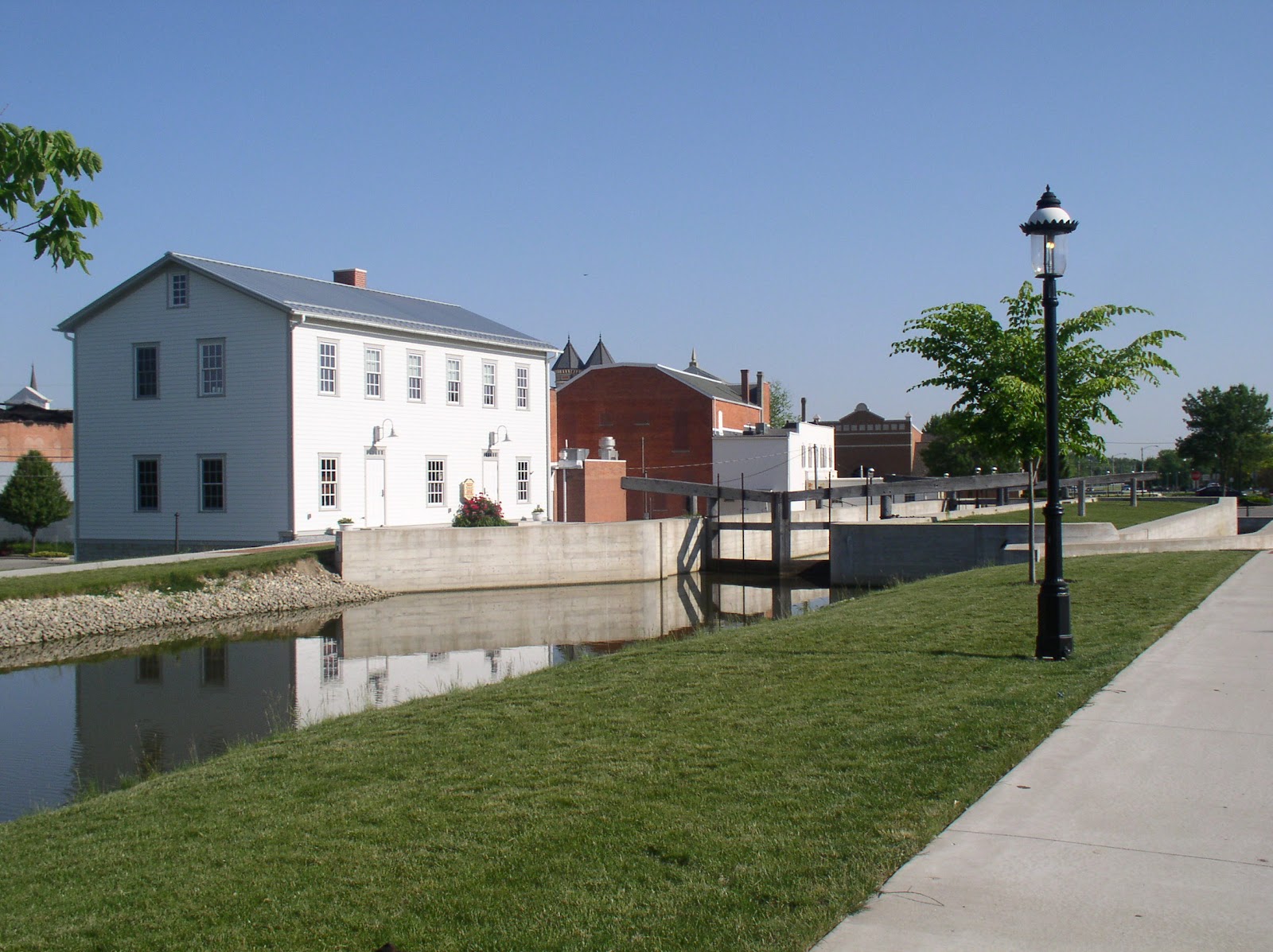
The photo on the left shows Lock 1 North which is located in the heart of the town. The large building to the left of the lock is a reconstructed lockhouse which looks similar to the original lockhouse. The lock has been cleaned up and reconstructed to provide a view of how it was constructed. The original lock was built out of limestone whereas the new one is poured concrete. The locks themselves are similar in construction to how they were built and how they worked.
In May, 1828, Congress signed a grant giving 50,000 acres of land from Dayton to Defiance that was used to complete phase two of the canal called the Miami Extension. Finally in 1831, an additional grant was given which would extend it to Toledo. The complete construction took 20 years. There were 19 aqueducts which were built over some creeks and rivers and 103 canal locks, of which this one at New Bremen was one. Bridges that were built were either swivel or were built high enough for a canal boat to go under.

The day I was there was bright and sunny. The walk from New Bremen to Minster is about four miles. The path crosses one road through-way, but except for that the complete path is over this crushed limestone, making it an easy walk.
Once you leave the city limits, the towpath stays the same, but the canal is generally neglected and as you can see in the photo on the left,
there are now trees growing between the path and the canal itself. On a day like today the canopy provided some relief from the hot sun. I began at about 9 in the morning so finished fairly quickly depending upon your pace. It was a Saturday and there were a few runners and several bicyclists, but otherwise, the path was pretty much my own. While technology moves on, it is sad to realize that the canal nearly disappears on this walk sometimes due to over-growth reducing to a small stream.
Generally it is stagnant outside of the city as there is virtually no circulation of the water even though there are now a few small streams emptying into it. Here is what it looked like in some areas, overgrown with cattail plants and lush greenery. Most of the landscape is either farmland on one side and occasional houses or small industrial facilities on the other.
While there are lots of birds along the walk, the insect population seemed very low despite the temperature being in the eighties and next to the stagnant areas of the canal.
Occasionally, there were pleasant surprises as this large turtle sitting by the edge of the path. I wasn't sure what he was up to as I would have thought he was dead except his eyes were wide open and he was just sitting there. Either he was warming himself, or laying eggs. While I don't know turtles, this could have been a box turtle because I know they lay eggs in the spring.
Historically along the canals there were different industries. As I mentioned above, several were grain and slaughtered hogs. Another one was ice. Plants were built that housed ice which was covered with sawdust, stacked and loaded onto canal boats to be delivered to southern climates where ice may not have been as plentiful.
Along this walk was a restored building that used to be an ice facility. It was right next to the canal. The photo was taken slightly down the road near where there historically was a swinging bridge which allowed canal boats to pass or traffic over the canal.
As the walk came to an end just outside of Minster, one could continue into the town, but much of the walk would be along a road.
Sadly the canal at this point became mostly a drainage ditch with most of it covered up. This is supposed to become a small industrial park. The picture was taken at the road and behind me, not in the picture is a home built next to the former canal and a portion is part of the home's yard. No sign of the canal exists.
All along the length of the whole canal from Toledo to Cincinnati there are portions that still exist, sometimes in ruins. In other locations such as in Dayton, a road now runs the path of the canal. For some additional photos of the canal along the complete original path, there is this web site where you can even see pictures of New Bremen's lock before it was restored.
The area on which I walked is part of the Loramie Summit, the highest plateau of the whole original Miami-Erie Canal. It was a 21 mile plateau that was controlled by the lock at New Bremen and Lockington, Ohio. The summit section was fed by Indian and Loramie lakes. It raised the boats up to 513 feet from the start at Cincinnati and then down to 395 feet at Toledo.
If you like a bit of history and want to get some exercise, this is generally a pleasant place to visit. I would recommend April or May depending upon the complete season to avoid humidity and potentially mosquitos and gnats.
The photo on the left shows Lock 1 North which is located in the heart of the town. The large building to the left of the lock is a reconstructed lockhouse which looks similar to the original lockhouse. The lock has been cleaned up and reconstructed to provide a view of how it was constructed. The original lock was built out of limestone whereas the new one is poured concrete. The locks themselves are similar in construction to how they were built and how they worked.
History
The history of the Miami-Erie Canal in western Ohio is a feat of engineering of the time. Construction began in the early 1820s starting on a leg from Cincinnati to Dayton. This leg of the canal was a boon to industry in the area for providing goods and services that extended to the Ohio River. The small town of Franklin became a center for trade shipping grain, slaughtered hogs and other goods. To ride the canal boat from Dayton to Cincinnati made travel easier than the alternative stagecoach at the time. A fast trip by canal boat could take only 20 hours!In May, 1828, Congress signed a grant giving 50,000 acres of land from Dayton to Defiance that was used to complete phase two of the canal called the Miami Extension. Finally in 1831, an additional grant was given which would extend it to Toledo. The complete construction took 20 years. There were 19 aqueducts which were built over some creeks and rivers and 103 canal locks, of which this one at New Bremen was one. Bridges that were built were either swivel or were built high enough for a canal boat to go under.
Today
New Bremen has restored their lock and cleaned up the canal making sure within their city limits, the towpath is clear along the canal. The towpath has been covered with a fine grain crushed limestone which makes walking, running, or riding bicycles along the flat level trail easy.The day I was there was bright and sunny. The walk from New Bremen to Minster is about four miles. The path crosses one road through-way, but except for that the complete path is over this crushed limestone, making it an easy walk.
Once you leave the city limits, the towpath stays the same, but the canal is generally neglected and as you can see in the photo on the left,
there are now trees growing between the path and the canal itself. On a day like today the canopy provided some relief from the hot sun. I began at about 9 in the morning so finished fairly quickly depending upon your pace. It was a Saturday and there were a few runners and several bicyclists, but otherwise, the path was pretty much my own. While technology moves on, it is sad to realize that the canal nearly disappears on this walk sometimes due to over-growth reducing to a small stream.
Generally it is stagnant outside of the city as there is virtually no circulation of the water even though there are now a few small streams emptying into it. Here is what it looked like in some areas, overgrown with cattail plants and lush greenery. Most of the landscape is either farmland on one side and occasional houses or small industrial facilities on the other.
While there are lots of birds along the walk, the insect population seemed very low despite the temperature being in the eighties and next to the stagnant areas of the canal.
Occasionally, there were pleasant surprises as this large turtle sitting by the edge of the path. I wasn't sure what he was up to as I would have thought he was dead except his eyes were wide open and he was just sitting there. Either he was warming himself, or laying eggs. While I don't know turtles, this could have been a box turtle because I know they lay eggs in the spring.
Historically along the canals there were different industries. As I mentioned above, several were grain and slaughtered hogs. Another one was ice. Plants were built that housed ice which was covered with sawdust, stacked and loaded onto canal boats to be delivered to southern climates where ice may not have been as plentiful.
Along this walk was a restored building that used to be an ice facility. It was right next to the canal. The photo was taken slightly down the road near where there historically was a swinging bridge which allowed canal boats to pass or traffic over the canal.
As the walk came to an end just outside of Minster, one could continue into the town, but much of the walk would be along a road.
Sadly the canal at this point became mostly a drainage ditch with most of it covered up. This is supposed to become a small industrial park. The picture was taken at the road and behind me, not in the picture is a home built next to the former canal and a portion is part of the home's yard. No sign of the canal exists.
All along the length of the whole canal from Toledo to Cincinnati there are portions that still exist, sometimes in ruins. In other locations such as in Dayton, a road now runs the path of the canal. For some additional photos of the canal along the complete original path, there is this web site where you can even see pictures of New Bremen's lock before it was restored.
The area on which I walked is part of the Loramie Summit, the highest plateau of the whole original Miami-Erie Canal. It was a 21 mile plateau that was controlled by the lock at New Bremen and Lockington, Ohio. The summit section was fed by Indian and Loramie lakes. It raised the boats up to 513 feet from the start at Cincinnati and then down to 395 feet at Toledo.
If you like a bit of history and want to get some exercise, this is generally a pleasant place to visit. I would recommend April or May depending upon the complete season to avoid humidity and potentially mosquitos and gnats.
Sunday, January 1, 2012
Flat Fork Ridge - Caesar Creek
Residents of Ohio know that in December, the weather is about as wacky as things can get. I headed out to the Caesar Creek area this first day of 2012 to take in a hike in an area I hadn't previously visited. The area is called the Flat Fork Ridge Trail loop and follows around a Southwestern portion of what is called the Caesar Creek Basin.
The trip to the area displayed weather that was mostly heavily overcast with breaks in the clouds and an occasional sun peeking through. The temperature was in the mid-fifties (yes, this is December) and I ran into some sprinkles on the way. It seemed to be light and soon stopped bringing relief that I wouldn't be hiking in wet weather. To get to the Flat Fork Ridge area, one must pass over the Caesar Creek Dam. More about that later. By the time I reached the Trailhead parking area, things seemed to be looking up. The sun was shining.
Caesar Creek, A Brief History
Beginning in the middle 1960s. the Corp of Engineers began buying up land along little Caesar Creek, East of Waynesville, Ohio and north of Wellman. The area was known to flood often requiring some kind of flood control. It was decided that a dam would be built creating a huge lake area that would become known as Caesar Creek Reservoir. Not everyone was happy especially the residents of New Burlington, which would disappear 70 feet under the water. One newspaper referred to the disappearance of New Burlington as a "footnote to progress." Referring to people water-skiing on the lake, John Baskin, who wrote about the people of New Burlington said "The Village had largely been forgotten. Most of the pleasure seekers...would have been only mildly surprised if someone had told them they were water-skiing over a town." [From New Burlington: The Life and Death of an American Village, W.W. Norton publisher, 2000]
The dam was built in 1970 and is maintained by the Corp of Engineers along with the whole of Caesar Creek Reservoir, which has become a large recreational area including the many hiking trails surrounding it. The reservoir extends 15 miles northward from the dam.
The initial part of the trail was easy and uneventful. This is the portion that is near the picnic grounds allowing non-hikers to enjoy views of the reservoir and to be able to walk around including intermittent benches to sit and view the area. The clouds were moving rapidly and still occasional sunshine would burst out affording some beautiful views of nature in hibernation as we inch toward a harder winter than what I was experiencing at that time. After all, the start of winter was only December 22nd, nine days ago.
After about a quarter mile walk, you approach what is called the Wellman Meadow. The plain is a low very flat basin that is actually a flood spillway if the water did have to rise. It sits between walls of shale carved out of the hills. U.S. 73 is in the view and across from that is an area that allows one to look for fossils as there were many ancient sea creatures now cast in stone for collecting.
Unfortunately, for me, there had been a hard rain earlier as well as several previous days of rain leaving the meadow area full of mud and water. One could either trudge directly through it or try to walk along thicker grassy portions to avoid sinking into small pools of collected water.
Another quarter mile and the trail begins to rise into slightly forested area. As with the meadow area, the trail was slippery and muddy. This was pretty much the case for the rest of the hike. The trail is marked by spray-painted markers on trees as there are occasional trail forays to the water level that could be reached. Additionally, the few wood bridge crossings were very slippery and I found it easier to just cross via rocks sticking up from the small tributary lines weaving their way to the creek.
The views of the creek were lovely along with a small horseshoe falls. The creek was swollen as it is during this period that the reservoir is beginning to be lowered to prepare for coming Spring rains. The dam was allowing the water to flow freely.. If one wanted to ford the creek, it was pretty impossible at this time due to the rushing water.
The length of this trail from the beginning to Pioneer Village and back would be six miles. However, the care of the trail has not been good. About a mile into the walk, there is supposed to be a suspension bridge. Unfortunately, the bridge is no longer there. It apparently became impossible to cross and unsafe and was dismantled. Nothing to this date has replaced it. Here is what I encountered on my hike.
I moved on down the trail. It was a bit precarious as the trail begins to fade out and is close to the edge of a 15 foot drop. Given the muddy, slippery bit, I found there was no place to forge the creek. I decided to give up and head back. Encouraging me was that the weather once more turned and began to rain heavily only making the trail worse while I was getting soaked.
As I headed back the wind rose in huge gusts as much colder air masses were moving in that would ultimately drive the temperature to the high 20s. The rain let up, but for the most part it was a miserable return hike.
I want to return to this trail area in the spring on some sunnier, drier day to try to explore the trail a bit more. Perhaps the creek will be less water clogged allowing me to forge it so I can complete the trail run. Until that bridge is replaced, this trail is probably not one to recommend.
I wonder if perhaps I was witnessing some of the area attempting to return to its own natural state and perhaps the ghosts of New Burlington were calling.
The trip to the area displayed weather that was mostly heavily overcast with breaks in the clouds and an occasional sun peeking through. The temperature was in the mid-fifties (yes, this is December) and I ran into some sprinkles on the way. It seemed to be light and soon stopped bringing relief that I wouldn't be hiking in wet weather. To get to the Flat Fork Ridge area, one must pass over the Caesar Creek Dam. More about that later. By the time I reached the Trailhead parking area, things seemed to be looking up. The sun was shining.
Caesar Creek, A Brief History
Beginning in the middle 1960s. the Corp of Engineers began buying up land along little Caesar Creek, East of Waynesville, Ohio and north of Wellman. The area was known to flood often requiring some kind of flood control. It was decided that a dam would be built creating a huge lake area that would become known as Caesar Creek Reservoir. Not everyone was happy especially the residents of New Burlington, which would disappear 70 feet under the water. One newspaper referred to the disappearance of New Burlington as a "footnote to progress." Referring to people water-skiing on the lake, John Baskin, who wrote about the people of New Burlington said "The Village had largely been forgotten. Most of the pleasure seekers...would have been only mildly surprised if someone had told them they were water-skiing over a town." [From New Burlington: The Life and Death of an American Village, W.W. Norton publisher, 2000]
The dam was built in 1970 and is maintained by the Corp of Engineers along with the whole of Caesar Creek Reservoir, which has become a large recreational area including the many hiking trails surrounding it. The reservoir extends 15 miles northward from the dam.
The initial part of the trail was easy and uneventful. This is the portion that is near the picnic grounds allowing non-hikers to enjoy views of the reservoir and to be able to walk around including intermittent benches to sit and view the area. The clouds were moving rapidly and still occasional sunshine would burst out affording some beautiful views of nature in hibernation as we inch toward a harder winter than what I was experiencing at that time. After all, the start of winter was only December 22nd, nine days ago.
After about a quarter mile walk, you approach what is called the Wellman Meadow. The plain is a low very flat basin that is actually a flood spillway if the water did have to rise. It sits between walls of shale carved out of the hills. U.S. 73 is in the view and across from that is an area that allows one to look for fossils as there were many ancient sea creatures now cast in stone for collecting.
Unfortunately, for me, there had been a hard rain earlier as well as several previous days of rain leaving the meadow area full of mud and water. One could either trudge directly through it or try to walk along thicker grassy portions to avoid sinking into small pools of collected water.
Another quarter mile and the trail begins to rise into slightly forested area. As with the meadow area, the trail was slippery and muddy. This was pretty much the case for the rest of the hike. The trail is marked by spray-painted markers on trees as there are occasional trail forays to the water level that could be reached. Additionally, the few wood bridge crossings were very slippery and I found it easier to just cross via rocks sticking up from the small tributary lines weaving their way to the creek.
The views of the creek were lovely along with a small horseshoe falls. The creek was swollen as it is during this period that the reservoir is beginning to be lowered to prepare for coming Spring rains. The dam was allowing the water to flow freely.. If one wanted to ford the creek, it was pretty impossible at this time due to the rushing water.
The length of this trail from the beginning to Pioneer Village and back would be six miles. However, the care of the trail has not been good. About a mile into the walk, there is supposed to be a suspension bridge. Unfortunately, the bridge is no longer there. It apparently became impossible to cross and unsafe and was dismantled. Nothing to this date has replaced it. Here is what I encountered on my hike.
I moved on down the trail. It was a bit precarious as the trail begins to fade out and is close to the edge of a 15 foot drop. Given the muddy, slippery bit, I found there was no place to forge the creek. I decided to give up and head back. Encouraging me was that the weather once more turned and began to rain heavily only making the trail worse while I was getting soaked.
As I headed back the wind rose in huge gusts as much colder air masses were moving in that would ultimately drive the temperature to the high 20s. The rain let up, but for the most part it was a miserable return hike.
I want to return to this trail area in the spring on some sunnier, drier day to try to explore the trail a bit more. Perhaps the creek will be less water clogged allowing me to forge it so I can complete the trail run. Until that bridge is replaced, this trail is probably not one to recommend.
I wonder if perhaps I was witnessing some of the area attempting to return to its own natural state and perhaps the ghosts of New Burlington were calling.
Monday, April 25, 2011
Serpent Mound and Adams County
Last week I visited several locations in Adams County in Ohio which offered moderate hiking, but lovely nonetheless. I had two reasons to visit these places: I was looking for some of the early spring flowers; and I am recovering from some knee pain, so I couldn't get into any strenuous hike.
The air is like a butterfly
With frail blue wings.
The happy earth looks at the sky
And sings - Joyce Kilmer
This has been a particularly wet April and the early spring flowers are just now beginning to come out. One place I had been meaning to visit is the historical Serpent Mound in Northern Adams County. The Great Serpent Mound is what is called an effigy mound meaning piled earth in the form of some creature - in this case a giant snake.
Over 1300 feet long, this sinuous serpents wends its way along ending in the head which faces out over a large limestone outcropping facing toward the Summer Solstice Sunset.
It is the largest effigy mound in the world and is believed to have been built by the Ft. Ancient culture that existed in Ohio around 1000 AD. There have been no human remains found on the site and is believed to have been a worshipping site by the culture tied around astrological wonders. The Cherokee culture believed in the power of the horned serpent who wielded supernatural powers though some groups believed the snake to be tied to the sky gods and thus possibly the astrological tie-in.
Visiting the Serpent Mound not only affords the opportunity to wander over the area next to the mound, but also there is a short hiking trail that is somewhat primitive and winds downward below the area of the mound within the Brush Creek basin.
Since there has been much rain, portions of the trail were flooded, though I was able to step around and through a rather sometimes muddy area and look at many of the early Spring flowers including the magnificent large Snow Trillium.
In addition to the Snow Trillium, the Ohio state wildflower, there were also what appeared to be Virginia Bluebells, Bellwort and Larkspur. The flowers were ubiquitous.

Here in Ohio, we are lucky to have such a magnificent site to visit if you have any inclination toward the history and pre-history of the state. Serpent Mound is off State Route 73 which passes through Adams County toward the Arc of Appalachia nearer to the Shawnee National Forest. However, at this point the hills are still gently rolling giving some excitement to the surrounding landscape, but nothing on par with being farther south.
Saturday, January 29, 2011
Stopping by the woods...
Whose woods these are I think I know.
His house is in the village though;
He will not see me stopping here
To watch his woods fill up with snow.
- Robert Frost
There's always something wonderful about being in the woods on a snowy day, hiking with the cornstarch crunch of snow under your feet; Surrounded by the gentle cold breeze whisping through the trees and the occasional call of a snow bird. But most of all is the quiet.
This week I spent some time in the Caesar's Creek Nature Preserve with the woods to myself. It is a gentle hike though moving through six inches of snow on the ground can be taxing on the legs over time. Hiking in snow, one doesn't have the sure foot of ground below as you move up or down the hills that make up this quiet location. While others have trod before me, it was a pleasure to see the revealing tracks of various wood creatures be it deer, winter rabbits, racoons and other smaller creatures. I knew I wasn't completely alone with a rather large doe leaped at least 8 feet across the wide path before me. In an instant she was gone blending invisibly into the background.
I especially like hiking where I will pass by a quiet burbling stream as with this one except the stream is the Little Miami River at a low point, but beginning to run more
But, alas, though it is pleasant, one cannot dawdle as poet Frost continued:
The woods are lovely, dark and deep.
But I have promises to keep,
And miles to go before I sleep,
And miles to go before I sleep.
Sunday, November 21, 2010
Late Autumn Visit to John Bryan State Park
There's something particularly warming about spending time in nature at this time of the year. Pretty much all the leaves have fallen, leaving the soft crunch of dead leaves on the paths; 
the honeysuckle which seems to survive any time of the year is still showing green leaves and a few faded flowers occasionally can still be seen.
I had to get away from my daily grind for one day at this time and this day seemed perfect. The only problem is that it was perfect for many others too.
It was an extremely bright, cool day and I thought I would have some sense of quiet, but the park is still filled with many weekenders taking large groups of children for a stroll through this park. Some of the trail is very easy, making it a good opportunity for a sort of "get away" with the kids. I just wanted wanted to walk and take the occasional photo, but it seemed in some ways like city traffic. I passed one group of probably 20 young people with a couple of adults.
Which is why I also like to go in January when it is too cold for any but the hearty. I'm looking forward to that time when the river waters are shallow and often frozen.
John Bryan affords large cliff rocks with some challenges if you walk all the way from one end into the Clifton Gorge area where the Little Miami River narrows tremendously and the paths are very rocky and with lots of ups and downs.
Despite the leave-less trees, on a day like this, the colors though very muted are still a delight when looking across the small river.

the honeysuckle which seems to survive any time of the year is still showing green leaves and a few faded flowers occasionally can still be seen.
I had to get away from my daily grind for one day at this time and this day seemed perfect. The only problem is that it was perfect for many others too.

It was an extremely bright, cool day and I thought I would have some sense of quiet, but the park is still filled with many weekenders taking large groups of children for a stroll through this park. Some of the trail is very easy, making it a good opportunity for a sort of "get away" with the kids. I just wanted wanted to walk and take the occasional photo, but it seemed in some ways like city traffic. I passed one group of probably 20 young people with a couple of adults.
Which is why I also like to go in January when it is too cold for any but the hearty. I'm looking forward to that time when the river waters are shallow and often frozen.
John Bryan affords large cliff rocks with some challenges if you walk all the way from one end into the Clifton Gorge area where the Little Miami River narrows tremendously and the paths are very rocky and with lots of ups and downs.
Despite the leave-less trees, on a day like this, the colors though very muted are still a delight when looking across the small river.
Saturday, August 28, 2010
Fort Hill - in the Arc of Appalchia
Today I spent a day hiking in the Arc of Appalachia, in Southern Ohio where the foothils of the Appalachians begin.
This is an area that has been preserved by the Ohio Department of Natural Resources and the Ohio Historical Society among others to maintain the native temperate forest of Ohio in a state prior to the migration of the white man into the region. The area offers hiking trails in highly protected areas, one of which is Fort Hill.
Fort Hill is a 1200 acre park and includes the Earthworks constructed 2000 years ago by what is now believed to be members of the Hopewell culture. While it is now believed not to have been a Fort at all, but rather a ceremonial gathering space, there are still remnants of a wall along the rim of the ridge.
On one side, the ridge falls off substantially downward, but on the other side is a large ditch remnant as it rises again on the inside to the flatter area even though it is all now covered with forestation. Fort Hill preserves one of the largest and oldest examples of native forest to be found in southern Ohio.
Hopewell is a European name that was given to these people and there is no archeological evidence of what they called themselves. It is believed now that some American Indian tribes, formerly of the area including the Shawnee are ancestors of these people.
There are in effect 3 trails one could take through this area. One is called the Deer Trail, which is not always open during hunting season. It is the longest at 6.5 miles. The second one is the Gorge Trail which is 4.2 miles and follows the rockscapes of Bakers Fork.
The last is the Fort Trail, which is 2.2 miles. This was the trail I primarily followed. One note is that the trails are not well marked. It had been my intention to follow the Gorge Trail, but apparently I took a wrong turn somewhere and ended up on the Fort Trail. This and the Gorge Trail begins from the parking area with an immediate 400 foot climb gradually but sometimes at angles of 45 degrees up the side of the hill. There are a few switchbacks, but much of it is nearly straight up.
One near the top, you begin to follow a slightly up and down trail that is for the most part primitive enough that I lost my way in terms of which trail I was on. I headed off on what I thought was the Gorge Trail and it came to an abrupt end, so I had to back track to the other trail I saw. This apparently was the Fort Trail. As I indicated, things are not well marked.
One problem that made this hike decision as to which trail was that I drove 90 minutes to get to the location. Knowing I had 90 minutes to drive back, my time on the trail was limited since I could not spend as much time as I hoped. I want to get back to this area sometime in the future. The location is about 70 miles east of Cincinnati and about 80 miles from the Eastern edge of Dayton. Most of the drive is on smaller state and township roads, so the driving is a little slower going.
As this was late August, there was little in the way of floribunda and the area was quite dry. A little bug spray kept the little critters who like to land and bite at bay.
Things were moderate enough that the humidity levels were low making the hiking a little easier than some of the more recent trips I have been on. I didn't meet anyone else on the trail, so for the most part, it is a solitary trip unless you are with a group of your own. As usual I felt as if I had the place to myself. I did hear a few distant voices but down the ridge, so I suspect they might have been people in the creek area, which I didn't see at all.
If you don't mind the drive, it is a pleasant area and I suspect a delight in the Spring. If you are lucky enough to live in the area, the Serpent Mounds, another ancient Earthwork is nearby.
This is an area that has been preserved by the Ohio Department of Natural Resources and the Ohio Historical Society among others to maintain the native temperate forest of Ohio in a state prior to the migration of the white man into the region. The area offers hiking trails in highly protected areas, one of which is Fort Hill.
Fort Hill is a 1200 acre park and includes the Earthworks constructed 2000 years ago by what is now believed to be members of the Hopewell culture. While it is now believed not to have been a Fort at all, but rather a ceremonial gathering space, there are still remnants of a wall along the rim of the ridge.
Hopewell is a European name that was given to these people and there is no archeological evidence of what they called themselves. It is believed now that some American Indian tribes, formerly of the area including the Shawnee are ancestors of these people.
There are in effect 3 trails one could take through this area. One is called the Deer Trail, which is not always open during hunting season. It is the longest at 6.5 miles. The second one is the Gorge Trail which is 4.2 miles and follows the rockscapes of Bakers Fork.
The last is the Fort Trail, which is 2.2 miles. This was the trail I primarily followed. One note is that the trails are not well marked. It had been my intention to follow the Gorge Trail, but apparently I took a wrong turn somewhere and ended up on the Fort Trail. This and the Gorge Trail begins from the parking area with an immediate 400 foot climb gradually but sometimes at angles of 45 degrees up the side of the hill. There are a few switchbacks, but much of it is nearly straight up.
One near the top, you begin to follow a slightly up and down trail that is for the most part primitive enough that I lost my way in terms of which trail I was on. I headed off on what I thought was the Gorge Trail and it came to an abrupt end, so I had to back track to the other trail I saw. This apparently was the Fort Trail. As I indicated, things are not well marked.
One problem that made this hike decision as to which trail was that I drove 90 minutes to get to the location. Knowing I had 90 minutes to drive back, my time on the trail was limited since I could not spend as much time as I hoped. I want to get back to this area sometime in the future. The location is about 70 miles east of Cincinnati and about 80 miles from the Eastern edge of Dayton. Most of the drive is on smaller state and township roads, so the driving is a little slower going.
As this was late August, there was little in the way of floribunda and the area was quite dry. A little bug spray kept the little critters who like to land and bite at bay.
Things were moderate enough that the humidity levels were low making the hiking a little easier than some of the more recent trips I have been on. I didn't meet anyone else on the trail, so for the most part, it is a solitary trip unless you are with a group of your own. As usual I felt as if I had the place to myself. I did hear a few distant voices but down the ridge, so I suspect they might have been people in the creek area, which I didn't see at all.
If you don't mind the drive, it is a pleasant area and I suspect a delight in the Spring. If you are lucky enough to live in the area, the Serpent Mounds, another ancient Earthwork is nearby.
Sunday, May 30, 2010
Twin Valley Metropark
When through the woods, and forest glades I wander,
And hear the birds sing sweetly in the trees.
When I look down, from lofty mountain grandeur
And see the brook, and feel the gentle breeze.
Then sings my soul, My Saviour God, to Thee,
How great Thou art, How great Thou art.
-- Carl Bobert, 1886
This week I visited the Twin Valley Metropark which is the southern section of the Twin Creek Metropark district. The northern section is Germantown Metropark, which I have written about previously.
Twin Valley is just off Eby Road south of the village of Germantown in the extreme southwestern portion of Montgomery County, Ohio. On this sparkling but hot day with new growth in full force, the hiking proved a humid and somewhat exhausting experience.
This park has a little of everything for naturalist, hiker and backpacker. Twin Creek is considered a backpacker's park as it has not only overnight camping areas, but well over 40 miles of hiking trails. For hikers it runs the gamut of young successional woods, mature old growth forest, grassland prairies and wetlands.
The portion of the trail I hiked this day roughly 5 miles tasted a little of all of these land characteristics. From where I parked, the trail begins at the peak of a hill offering a wide view of the valley below.
It descends almost immediately first through grassy plains on the hillside then to the start of the forested area as I approach Twin Creek, one of Ohio's cleanest. The trail I chose first followed the creek. This is bottomland hiking and though it was a hot dry day, portions of the trail were still muddy. There is a portion of this trail that allows horseback riding and unfortunately, it tended to create clogs and pockets of dirt making walking that portion of the trail a little more difficult to navigate. I almost wish they would keep the horseback riding confined to its own trails.
For the most part the pathway is dirtpacked though narrow. It covers a vast amount of both flatland, winding narrow ridge climbing about 100 feet in a short distance, up and down the ridgeways, sometimes along precarious passageways with steep slopes back toward the bottomland where on wetter days, one would have to be extremely careful (a hiking stick comes in handy in these areas). Portions of the trail are difficult climbing though the trails are set up in such a way that one could select a more moderate leg if you wanted to enjoy the area without much difficult hiking.
When in the bottomlands along the flood plain, the trail breaks into grassy plains that have the trail moderately mowed so you can continue to follow it. There are the requisite posts alerting you to the trail, which soon moves back into the forested hills as you begin the trek upward toward the ridge peaks.
This time of the year affords a number of flora though with the shading of the trees, some of the flowering is limited. Still, there are wonderful odors of nature as one moves past the various plant growth. While in the prairie areas, there were numerous butterfly swirling about occasionally landing long enough to pose for a photograph. While in the bottomlands where things are much more humid and wet, I came across a number of toads.
The only downside of hiking at this time of the day - just before noon - in the humid areas of the forested pathway, I was plagued at times by flies and gnats, some rather aggressive. This seemed mostly when I was on the portion of the trail where horses are allowed to move. I am sure flies cannot distinguish from one large mammal to another!
One of the nice things about this park are hidden gems you can encounter. I did pass a historical area where the Hopewell Indians over 2000 years ago had built up walls to fortify one of their encampments. While the area is indicated on the map, it is not marked along the trail. I found, what I think were remnants of the wall, now a small area rising upwards along the ridge. It would have been nice to mark the trail with indications of what one might look for to better help imagine the area as it might have been when the Hopewell Indians walked the area. There is new evidence that the Hopewells were the ancestors of the Shawnee Indian tribes who lived in this area in the 17th and 18th centuries.
While walking up out of the bottomlands, I came across - hidden among the wooded area
- the Dogwood Pond, a cool clear fishing spot. While not a fisherman, it provided a perfect spot for relaxing for a while as it is partially shaded. There were a couple of people fishing, but it is remote enough that one has to do a little hiking to get to it. That seems to keep most fisherman out of the area.
Twin Valley Trails is fast becoming one of my favorite close-by places to hike. It affords enough difficulty, pleasant surprises, multiple examples of nature, and a
little history. There are other places with more of any one of those, but none with so complete a mix of all. The trails are designed that you can take a small walk, or an extended hike. It is a hiking area in which you have to be careful as you move along the trail, or one where it is a pleasant walk in the woods along a clear creek. The park is well maintained and the trails are kept up for the most part by a full time staff.
For more photos of this hike go to here.
And hear the birds sing sweetly in the trees.
When I look down, from lofty mountain grandeur
And see the brook, and feel the gentle breeze.
Then sings my soul, My Saviour God, to Thee,
How great Thou art, How great Thou art.
-- Carl Bobert, 1886
This week I visited the Twin Valley Metropark which is the southern section of the Twin Creek Metropark district. The northern section is Germantown Metropark, which I have written about previously.
Twin Valley is just off Eby Road south of the village of Germantown in the extreme southwestern portion of Montgomery County, Ohio. On this sparkling but hot day with new growth in full force, the hiking proved a humid and somewhat exhausting experience.
This park has a little of everything for naturalist, hiker and backpacker. Twin Creek is considered a backpacker's park as it has not only overnight camping areas, but well over 40 miles of hiking trails. For hikers it runs the gamut of young successional woods, mature old growth forest, grassland prairies and wetlands.
The portion of the trail I hiked this day roughly 5 miles tasted a little of all of these land characteristics. From where I parked, the trail begins at the peak of a hill offering a wide view of the valley below.
It descends almost immediately first through grassy plains on the hillside then to the start of the forested area as I approach Twin Creek, one of Ohio's cleanest. The trail I chose first followed the creek. This is bottomland hiking and though it was a hot dry day, portions of the trail were still muddy. There is a portion of this trail that allows horseback riding and unfortunately, it tended to create clogs and pockets of dirt making walking that portion of the trail a little more difficult to navigate. I almost wish they would keep the horseback riding confined to its own trails.
For the most part the pathway is dirtpacked though narrow. It covers a vast amount of both flatland, winding narrow ridge climbing about 100 feet in a short distance, up and down the ridgeways, sometimes along precarious passageways with steep slopes back toward the bottomland where on wetter days, one would have to be extremely careful (a hiking stick comes in handy in these areas). Portions of the trail are difficult climbing though the trails are set up in such a way that one could select a more moderate leg if you wanted to enjoy the area without much difficult hiking.
When in the bottomlands along the flood plain, the trail breaks into grassy plains that have the trail moderately mowed so you can continue to follow it. There are the requisite posts alerting you to the trail, which soon moves back into the forested hills as you begin the trek upward toward the ridge peaks.
This time of the year affords a number of flora though with the shading of the trees, some of the flowering is limited. Still, there are wonderful odors of nature as one moves past the various plant growth. While in the prairie areas, there were numerous butterfly swirling about occasionally landing long enough to pose for a photograph. While in the bottomlands where things are much more humid and wet, I came across a number of toads.
The only downside of hiking at this time of the day - just before noon - in the humid areas of the forested pathway, I was plagued at times by flies and gnats, some rather aggressive. This seemed mostly when I was on the portion of the trail where horses are allowed to move. I am sure flies cannot distinguish from one large mammal to another!
One of the nice things about this park are hidden gems you can encounter. I did pass a historical area where the Hopewell Indians over 2000 years ago had built up walls to fortify one of their encampments. While the area is indicated on the map, it is not marked along the trail. I found, what I think were remnants of the wall, now a small area rising upwards along the ridge. It would have been nice to mark the trail with indications of what one might look for to better help imagine the area as it might have been when the Hopewell Indians walked the area. There is new evidence that the Hopewells were the ancestors of the Shawnee Indian tribes who lived in this area in the 17th and 18th centuries.
While walking up out of the bottomlands, I came across - hidden among the wooded area
- the Dogwood Pond, a cool clear fishing spot. While not a fisherman, it provided a perfect spot for relaxing for a while as it is partially shaded. There were a couple of people fishing, but it is remote enough that one has to do a little hiking to get to it. That seems to keep most fisherman out of the area.
Twin Valley Trails is fast becoming one of my favorite close-by places to hike. It affords enough difficulty, pleasant surprises, multiple examples of nature, and a
little history. There are other places with more of any one of those, but none with so complete a mix of all. The trails are designed that you can take a small walk, or an extended hike. It is a hiking area in which you have to be careful as you move along the trail, or one where it is a pleasant walk in the woods along a clear creek. The park is well maintained and the trails are kept up for the most part by a full time staff.
For more photos of this hike go to here.
Sunday, May 16, 2010
Shawnee Lookout
On a recent fantastic Spring Saturday, I drove down to the extreme southwest area of Ohio where Ohio, Indiana and Kentucky meet. I stayed on the Ohio side and visited the Hamilton County Parks area known as Shawnee Lookout.
There are three hiking trails, none of which are difficult and in fact except for a few up and down ridge hills, are pretty much clear and in places have gravel to make this a family-oriented walking experience.
What is amazing about the park and what attracted me were some of the views you can get of where the Great Miami River meets the mighty Ohio. There is a lot of history in this area. It was the hunting grounds of the Shawnee Indians in the 18th century before it was invaded by the European settlers. Before that it was the living and burial areas of the early Hopewell cultures. There are a number of burial mounds that are somewhat obscured by overgrowth. The longest single trail is about 2 miles.
The history of the area is most fascinating. The area has been the site of a number of digs by the University of Cincinnati archeology department. The Lookout area was the largest continuously occupied hilltop settlement established by any Native American group. According to the digs, the Hopewell who occupied the area over 2000 years ago are seen to be a direct
link to the Shawnee who inhabited the area in the 18th century. One of the trails in the lookout take you to the ancient Miami Fort, thought to have been built by the Adena Hopewell possibly as a ceremonial site rather than a military one. As you walk around the lands of the fort, you can see remnants of the ancient walls. The location sits atop a hill over the area where the Great Miami and Ohio Rivers meet.
Just down the hillside on land that is now where the Duke Energy power plant exists was the location of Fort Finney. This Fort's importance was the location of a meeting between the Shawnee and the new American government in 1786. A treaty was reluctantly agreed to by the Shawnee over their homelands after they indicated they were going to war against the Americans over the land which had been promised previously was Shawnee territory. However, under threat of superior military power, the Shawnee were forced to agree to be subverted within the American land. The tribe found it had no authority over its own lands.
The vistas from the various trails are spectacular. Off one trail, you can see the floodplain formed by the Great Miami where it meets the Ohio.
The area is home to over 80 species of fish, 500 species of moths and butterflies as well as multiple birds.
The three trails are all easily accomplished within a day. The park also has other features for families including the log cabin of Micajah Duncan built out of split Oak logs for his home in Elizabethtown, Ohio nearby. The cabin was moved here for preservation.
The Shawnee Lookout Park is worth a look especially if you want to walk the trails among history.
There are three hiking trails, none of which are difficult and in fact except for a few up and down ridge hills, are pretty much clear and in places have gravel to make this a family-oriented walking experience.
What is amazing about the park and what attracted me were some of the views you can get of where the Great Miami River meets the mighty Ohio. There is a lot of history in this area. It was the hunting grounds of the Shawnee Indians in the 18th century before it was invaded by the European settlers. Before that it was the living and burial areas of the early Hopewell cultures. There are a number of burial mounds that are somewhat obscured by overgrowth. The longest single trail is about 2 miles.
The history of the area is most fascinating. The area has been the site of a number of digs by the University of Cincinnati archeology department. The Lookout area was the largest continuously occupied hilltop settlement established by any Native American group. According to the digs, the Hopewell who occupied the area over 2000 years ago are seen to be a direct
link to the Shawnee who inhabited the area in the 18th century. One of the trails in the lookout take you to the ancient Miami Fort, thought to have been built by the Adena Hopewell possibly as a ceremonial site rather than a military one. As you walk around the lands of the fort, you can see remnants of the ancient walls. The location sits atop a hill over the area where the Great Miami and Ohio Rivers meet.
Just down the hillside on land that is now where the Duke Energy power plant exists was the location of Fort Finney. This Fort's importance was the location of a meeting between the Shawnee and the new American government in 1786. A treaty was reluctantly agreed to by the Shawnee over their homelands after they indicated they were going to war against the Americans over the land which had been promised previously was Shawnee territory. However, under threat of superior military power, the Shawnee were forced to agree to be subverted within the American land. The tribe found it had no authority over its own lands.
The vistas from the various trails are spectacular. Off one trail, you can see the floodplain formed by the Great Miami where it meets the Ohio.
The area is home to over 80 species of fish, 500 species of moths and butterflies as well as multiple birds.
The three trails are all easily accomplished within a day. The park also has other features for families including the log cabin of Micajah Duncan built out of split Oak logs for his home in Elizabethtown, Ohio nearby. The cabin was moved here for preservation.
The Shawnee Lookout Park is worth a look especially if you want to walk the trails among history.
Saturday, April 3, 2010
A Return to Glen Helen
On the cusp of Spring, I decided to return to Glen Helen Nature Preserve at the end of March. Glen Helen is part of Antioch College which is currently closed, but hopes to re-open in 2012. However, the nature preserve remains open though they are hoping to raise the funds to make much needed repairs and clean up of the preserve. Still though it is a fascinating place to spend a glorious but chilly day the Saturday I visited.
Glen Helen is near Yellow Springs, Ohio which itself, like the preserve has a fascinating history. Named after a nearby natural spring from which water with a heavy iron content bursts forth giving the rock upon which it bubbles up a decidedly yellow cast. The spring was first visited by Native American Indians who lived and traveled in the area. Among some of the more famous Indians who passed through the area included the Shawnee Tecumseh, Blue Jacket, Blackfish and Little Turtle. The yellow spring was just a few miles from Chalahgawtha or Old Chillicothe, the principle village of one of the five divisions of the Shawnee tribe in the 18th century. This was where famous pioneers such as Daniel Boone and Simon Kenton were held prisoner by the Shawnee.
One of the first Yellow Springs residents was Lewis Davis, whose Inn served as a central point for mostly wealthy patrons from Cincinnati to venture to the town to take in the spring's waters, said to have curative powers. By 1826, one Elisha Mills bought surrounding land, including the Glen and began advertising "his auspicious “water cure” spa, just a day’s ride north by coach from Cincinnati." It was Mills who brought the railroad to the town - the tract of land is now part of the Little Miami Scenic Bike way.
The Glen land was purchased in the early 20th century by Hugh Birch, who had grown up playing around the area's wooded and limestone outcroppings. When his only surviving daughter, Helen died in 1925, Birch donated the land to Antioch College four years later in her honor as a place for study and enjoyment. The land was renamed Glen Helen and was to become a nature preserve.
My attraction to Glen Helen is the moderate hiking it affords where two creeks meet, steep but climbable ridges, gorge areas and the wonderful Cascades carved from one of the creeks provide enjoyment. Now as a nature preserve the trails are maintained, but full of lush greenery in the summer time.
When I visited on the recent Saturday, the deadness from winter still was holding the Glen in its grip, but there were hopeful signs of things to come including the few snow trillium I found just beginning to burst on the scene. Buds on the trees and some greening areas were certainly in abundance.
Right now the Glen is in some financial trouble. As Antioch tries to sort out its financial difficulties, the leaders of the Glen are trying to raise some funds to among other things, remove the increasingly invasive honeysuckle and clear up many downed trees from past years' storms.
But despite its problems, the Glen is still a fascinating place to spend some time communing with nature.
Glen Helen is near Yellow Springs, Ohio which itself, like the preserve has a fascinating history. Named after a nearby natural spring from which water with a heavy iron content bursts forth giving the rock upon which it bubbles up a decidedly yellow cast. The spring was first visited by Native American Indians who lived and traveled in the area. Among some of the more famous Indians who passed through the area included the Shawnee Tecumseh, Blue Jacket, Blackfish and Little Turtle. The yellow spring was just a few miles from Chalahgawtha or Old Chillicothe, the principle village of one of the five divisions of the Shawnee tribe in the 18th century. This was where famous pioneers such as Daniel Boone and Simon Kenton were held prisoner by the Shawnee.
One of the first Yellow Springs residents was Lewis Davis, whose Inn served as a central point for mostly wealthy patrons from Cincinnati to venture to the town to take in the spring's waters, said to have curative powers. By 1826, one Elisha Mills bought surrounding land, including the Glen and began advertising "his auspicious “water cure” spa, just a day’s ride north by coach from Cincinnati." It was Mills who brought the railroad to the town - the tract of land is now part of the Little Miami Scenic Bike way.
The Glen land was purchased in the early 20th century by Hugh Birch, who had grown up playing around the area's wooded and limestone outcroppings. When his only surviving daughter, Helen died in 1925, Birch donated the land to Antioch College four years later in her honor as a place for study and enjoyment. The land was renamed Glen Helen and was to become a nature preserve.
My attraction to Glen Helen is the moderate hiking it affords where two creeks meet, steep but climbable ridges, gorge areas and the wonderful Cascades carved from one of the creeks provide enjoyment. Now as a nature preserve the trails are maintained, but full of lush greenery in the summer time.
Right now the Glen is in some financial trouble. As Antioch tries to sort out its financial difficulties, the leaders of the Glen are trying to raise some funds to among other things, remove the increasingly invasive honeysuckle and clear up many downed trees from past years' storms.
But despite its problems, the Glen is still a fascinating place to spend some time communing with nature.
Thursday, March 11, 2010
Can Spring Be Around the Corner?
Now that our snow has begun to disappear and temperatures have been in the sixties for several days, it seems only a matter of time before nature begins is renewal cycle. Last week I visited a place I hadn't been to in months. In fact it had been long enough that I had to re-check my maps on where exactly it was located.
The site is the Caesar Creek Nature Preserve.
Within a short distance from me is the Caesar Creek area, where in the late Spring and Summer, large quantities of people come to enjoy their foray into the natural world. It is a huge boating area. But this is not the Caesar Creek area I usually travel to. The Nature Reserve area is south of the main vacation spot and has two elements that make it more ideal for hikers who want to commune with nature. First of all, it is connected to the Little Miami River bike path and the parking lot is a place for bikers to leave their cars as they ride the bikeway (a very nice area to bike, by the way). Secondly, this Nature Preserve does not allow bikes or pets in the wooded area, so it isn't as popular for the casual walker who wants to spend some time walking their pets.
When I went there last week, it was still cold (a good time to hike)
and as I said the snow was receding, but unfortunately, it was warm enough that some of the icy pathways were turning to mud, making for a messier hike. But it was another quiet peaceful time having the preserve to myself practically. I met one soulmate on the path who also liked coming for the isolation and sense of private ownership.
As with many of the parks and preserve that straddle the wonderfully scenic Little Miami River, it was an opportunity to hear the sounds of nature as it begins to adapt to the coming rumble of nature springing into life. The trees had small buds that were forming as they prepared to burst into small leaves.
The ground was soaked with wet much needed to the renewal process. I intend to spend some frequent visits to the area as it transforms itself into a fresh smelling area with wildflowers and other flora.
The site is the Caesar Creek Nature Preserve.
When I went there last week, it was still cold (a good time to hike)
As with many of the parks and preserve that straddle the wonderfully scenic Little Miami River, it was an opportunity to hear the sounds of nature as it begins to adapt to the coming rumble of nature springing into life. The trees had small buds that were forming as they prepared to burst into small leaves.
Saturday, February 27, 2010
A Winter Visit
"I prefer winter and fall, when you feel the bone structure of the
landscape - the loneliness of it, the dead feeling of winter.
Something waits beneath it, the whole story doesn't show."
- Andrew Wyeth
There is something wonderful about winter, when nature is in solitude, the beauty in its decay. Nature gives off the vibrations of things to come as winter withdraws and we are teased with the coming of Spring.
I enjoy going into the woods on a snowy day when sounds are muted and the birds can be viewed through the leafless trees and their songs clearly echoing throughout. I have been cooped up for a number of weeks due to the unusual volume of snow our area received over this past month of February. It was the second largest recorded snowfall over the month with over 21.4 inches mostly without much melting in-between. Today I awoke to a fresh 2 more inches on top of the already packed snow, so the woods had a fresh cover of the white stuff.
While I love hiking through woods when Spring is in full bloom, it is hiking in winter that adds the tension of things to come. I traveled nearby to Sugarcreek Metro Parks, a normally easy hiking area.
Today the trail was rutted and tromped down by previous hikers making it just a bit more difficult and easy to turn an ankle if one is not careful. But all things considered, it offers the starkness that only nature in winter time can present. One pleasant surprise was when I came upon a Pileated Woodpecker drilling for insects beneath the bark of the trees. I took some great video of the bird in action. Pileated woodpeckers are the largest species of woodpecker in North America and have a distinct red top to its grey coat which moves to a black and white striping of its head. The bird kindly worked from my angle of vision so that I could capture it at work.
My time out today helped give way to the cabin fever I have felt over the last month as I count the days before nature begins to break forth with early blooms and the overcast days become more sunny as the earth moves into position where the angle of the sun gradually begins to warm the ground and natural life begins anew.
Subscribe to:
Posts (Atom)


